The iD Editor
Reviewed 2019-06-10
Starting to map with a Tasking Manager for HOT or MissingMaps etc? See our HOT-tips section.
The iD is the browser-based OpenStreetMap editor. iD is fast and easy to use, and allows mapping from various data sources such as local knowledge, aerial imagery, GPS, Field Papers or Mapillary.
The iD editor is a great way to edit for small and easy changes that don’t require the advanced features of JOSM (a more advanced mapping editor). This chapter demonstrates the basics of editing with iD.
Starting the iD Editor
- The iD editor requires an active connection to the Internet.
- Open your Internet browser, and go to the OpenStreetMap website at http://www.openstreetmap.org.
- Login using your OpenStreetMap account
- Pan and zoom the map to the area that you wish to edit. You can pan by holding the left mouse button and dragging the map to your desired area.
- Click on the small arrow next to Edit. Then click Edit with iD (in-browser editor)
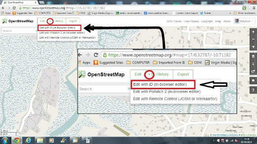
- You can select a default editor in your user preferences (click on your username at the top right corner of your browser, then choose ‘My preferences’). This allows you to start the editor by simply clicking on the Edit button.
iD Editor User Interface
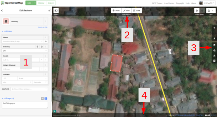
- Edit Feature Panel: This panel shows tags from the object selected on the map.
You can add or edit tags from this panel.
- Tools: This panel shows basic editing tools:
Draw point (node), shortcut key 1 
Draw line (way), shortcut key 2 
Draw shape (polygon), shortcut key 3 
Undo, shortcut keys Ctrl+z 
Redo, shortcut keys Ctrl+y 
Save changes, shortcut keys Ctrl+s 
- Map panel: This panel show various configuration functions:
Zoom In, shortcut key + 
Zoom Out, shortcut key - 
Go to your location 
Configure background layer, shortcut key b 
Map Data, shortcut key f 
Issues, shortcut key i 
Open Help Menu, shortcut key h 
- Information panel: This panel shows various information, such as the scale bar and which users have contributed to the area.
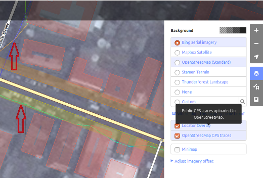
Configuring the Background Layer
Click the Background settings button or use the shortcut key b.
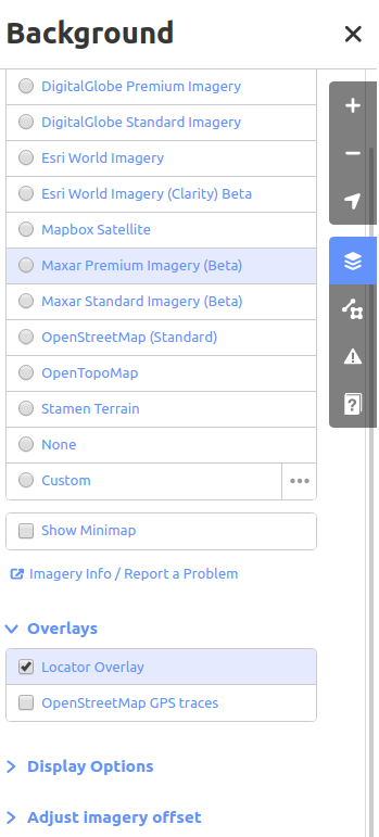
You can change the background layer based on your desired tile provider (the default is Bing Aerial Imagery).
You can add your own map tiles by clicking on Custom. For example, if you want to add a Field Paper , click Custom then click on the magnifying glass (search) icon to open the following window:-
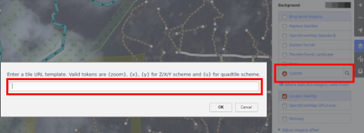
and enter your FieldPaper snapshot URL, which will be something like this: http://fieldpapers.org/snapshot.php?id=cqhmf2v9#18/37.80593/-122.22715
To display GPS tracks from your computer (GPX format), drag and drop the GPX file into iD editor.
To enable OpenStreetMap GPS traces click on the box. In the image below, public GPS traces are shown in various colors, indicating the direction of travel.
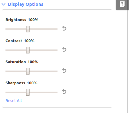
To change the appearance of the imagery click Display Options.
If there is imagery offset, you can correct the imagery offset by clicking Adjust imagery offset.
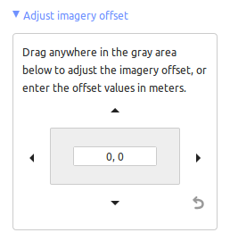
- Click the navigation buttons to move the imagery. Click the reset button to return to the default position.

Basic Editing with iD
Beware that the ID Editor hides objects when zoomed out. You will see a blue notice in the bottom of your screen warning you that there are ¨hidden features¨.
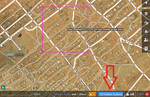 Zoom in until you see these features appear. Only then start mapping. Otherwise there is a chance you map objects on top of existing ones.
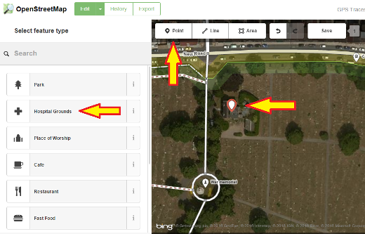
Adding Points
To add a new point, click on the Point button.
- Your mouse cursor will change into plus (+) sign. Now, click on a position that you know to mark a location. For example, if you know that there is a hospital in your area, click on the position of the hospital building.
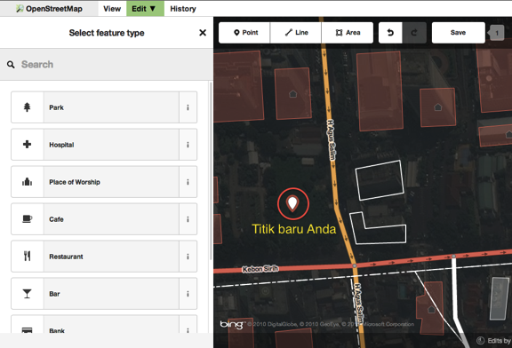
- Notice that a new point is added. At the same time, the left panel will change to show a form where you can select attributes for the object. Click Hospital Grounds to tag the point as a hospital.
- You can use the forms to fill detail information about your point. You can fill hospital name, address, and/or other additional information. Note that each feature will have different options, depending on what tag you choose from the feature panel.
- If you make a mistake, such as a wrong location, you can move your point to a new location by holding the left mouse button on your point and dragging it. Or, if you want to delete your point, click the left mouse button on the point, activate the context menu by clicking with the right mouse button and then click the button which looks like a trashcan.

A “point” created in the iD editor is actually a standalone “node” with a set of “tags” on it.
Drawing Lines
To add a new line, click on the Line button.
- Your mouse cursor will change into plus (+) sign. Find a road that hasn’t been drawn on the map and trace it. Click once on a point where the road segment begins, move your mouse, and click to add additional points. Double-click to end the drawing process. Notice the panel on the left.
- Just as with a point, select the appropriate tags for your line.
- You can drag points from the line by clicking your left mouse button on a point and dragging it.
- When you click your left mouse button on an individual point (node) on the line and either click on the right mouse button or hit the space bar to activate the context menu, you will see these tools:
- Continue line from this point

- Disconnect lines at this point

- Split a line into two lines at this point.

- Delete point from line.
- When you click your left mouse button on a line (but not on a point), you will see these tools:
- Create a circle from a line (only active if the line is closed)

- Disconnect line from other objects

- Move line

- Square all corners

- Reflect the line across its short axis

- Reflect the line across its long axis

- Reverse line direction (good for rivers & one-way streets)

- Rotate the line around its centre

- Straighten the line

- Delete line.

A “line” created in the iD editor is actually a “way” with “tags” on it.
A special note about Deleting: In general you should avoid deleting other people’s mapping if it just needs improvement. You can delete your own mistakes, but you should try to adjust other people’s mapped objects if they need changes. This preserves the history of the items in the OSM database and is respectful of fellow mappers. If you really feel something should be deleted, consider asking the original mapper or one of the OSM email lists about it first.
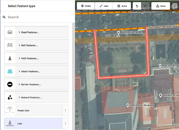
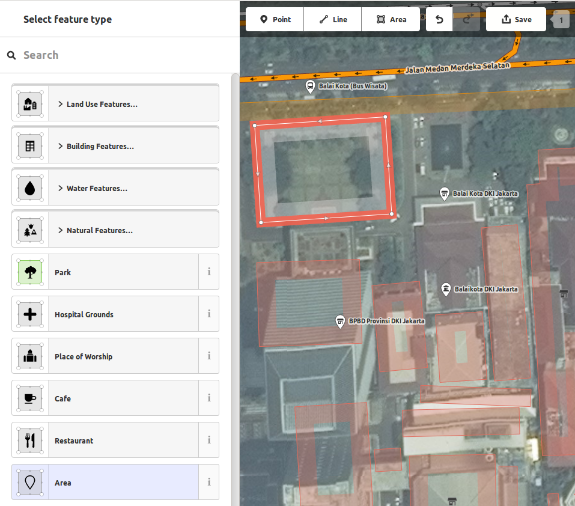
Drawing Shapes (Polygons)
To add a new multi-sided shape, click on the Area button. 
- Your mouse cursor will change into plus (+) sign. Try to trace a building using the imagery as a guide.
- You will notice that the color of your shape will change depending on the attributes that you assign to it.
- The tools that are available when you select a shape and activate the context menu with the right mouse button are similar to those when you click on a line.
A “polygon” in the iD editor is actually a “closed way” with tags on it.
Drawing Multipolygons
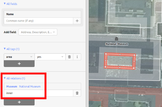
Sometimes you have to draw a polygon which does not only have an outer contour but also one or more inner contours. Just think of buildings with inner courtyards or lakes with islands. Do not draw all these ways in one line so that the inner contours suspend from the outer contour. Rather draw these contours separate, attach tags to the outer contour only, select all contours and hit c in order to combine them into what is called a multipolygon.
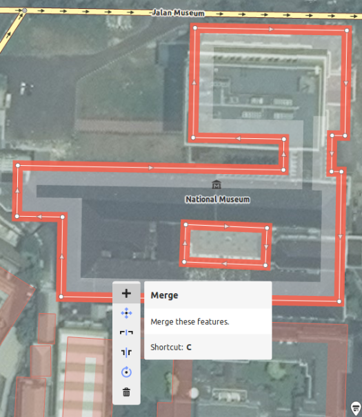
When you select any of the contours of the newly created multipolygon you can see on the left to which multipolygons it belongs
Issues
The editor performs a number of checks as soon as you edit something. If it thinks that what you did might cause problems it notifies you in the issues tab. Whenever the issues icon on the right carries either a yellow (for warnings) or red (for errors) dot you should open the tab and see what it reports. This information is also displayed in the object feature tab on the left if the relevant object is selected. You are also warned that there are unresolved issues when you upload your data.
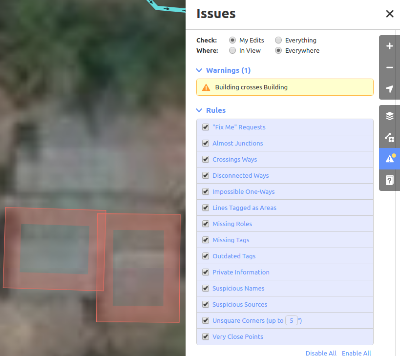
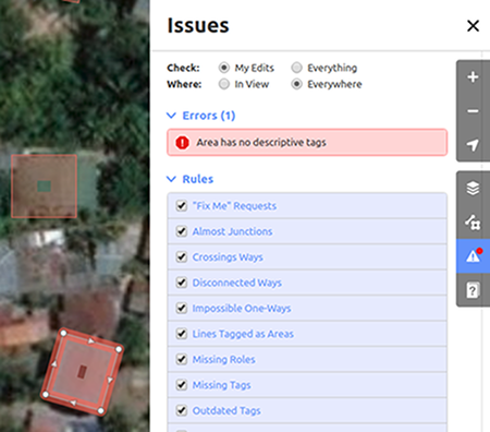
The lower part of the issues tab show the available rules and allows you to disable them individually though this is not recommended.
Saving Your Changes
When (and if) you want to save your edits to OpenStreetMap, click the Save button. The panel on the left will show the upload panel.
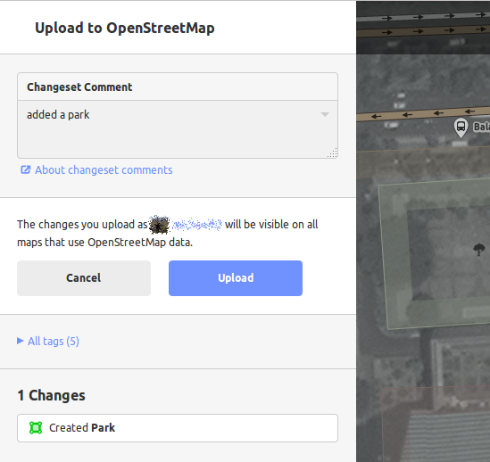
- Add a short description what you changed and why and then click Save. “Added houses based on aerial imagery” or “added adddresses based on survey” or “added footbridge based on survey, not yet visible in aerial imagery”
If you have edited the same feature (point, way or area) at the same time as another person was editing it, you will receive a warning that your edits cannot be uploaded until you have resolved the conflicts - choose whose edits to accept & upload your changes. Resolving conflicts often involves accepting the other persons edits, in which case you will probably wish to return to the feature in question and edit again (this time save soon after the edit to try to avoid a conflict again!).
When you are editing an object, you will see an “Add field” menu at the bottom of the attribute panel. You can add various additional information by selecting one of the entries (layer, elevation, wikipedia etc.).
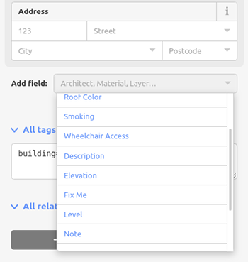
Or you can add custom tags by clicking All tags. 
- This will show all the tags attached to the feature.
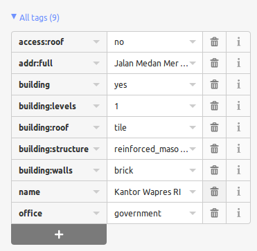
- Click the plus sign (+) to add keys and values or click the trash icon to delete tags.
Further tutorials
Our external resources page provides links to a number of video tutorials from various sources.
iD versus JOSM
iD is good for…
- When you are doing simple edits
- When you have fast Internet to load the imagery and save the edits
- When you want to be sure to follow a consistent and simple tagging scheme
- When you are restricted from installing a program on the computer you are using
JOSM is better…
- When you are adding many buildings (See buildings_tool plugin)
- When you are editing many polygons or lines that already exist
- When you are on an unreliable Internet connection or offline
- When you are using a specific tagging scheme (or custom presets)
