- Other guides
- Beginner's guide
- JOSM - Detailed Editing
- Coordination
- Mapping with a SmartPhone, GPS or Paper
- OSM Data
- OSM Data Overview
- File Formats
- Getting OSM Data
- Using Geofabrik and HOT Export
- Using OSM Data in QGIS
- Setting up PostgreSQL
- osm2pgsql
- Manipulating Data with Osmosis
- HOT Tips - Getting started for new mappers - iD editor
- Other Resources
|
|
File Formats
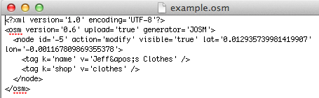
Like any type of data, there are various ways of storing geographic data on a computer. It can be saved in a database, which is a specialized system for storing and retrieving data, and in fact there are database systems specifically designed for storing geographic data. It can also be stored in traditional computer files, though there are many different file formats for geographic data. In this section we’ll go through a few ways of storing geographic data, explain how they work and how they’re typically used. .OSM FilesThe .osm file format is specific to OpenStreetMap. You won’t come across it elsewhere. If you have ever downloaded data using JOSM and saved it as a file, you may have noticed that the file is saved with the extension .osm. If you are a GIS user, you may also have noticed that it is not easy to open these files using software such as QGIS. So why is OSM data stored in a file format that nobody else uses? The answer is that many geographic data formats predate the modern internet era, and are designed for quick access and querying like one would query a database. OSM data, on the other hand is designed to be easily sent and received across the internet in a standard format. Hence, .osm files are coded in XML, and contain geographic data in a structured, ordered format. A simple .osm file would look like this if viewed in a text editor:
Acquiring data in .osm format is easy - in fact you do it every time that you download data in JOSM, but using these files for analysis and map design is not easy. Hence you are better off converting the data into another format, or getting it from a service that converts the data for you.
ShapefilesThe shapefile is a widely used format for storing vector geographic data. It was developed by ESRI, the company that makes ArcGIS, a popular suite of GIS applications. Shapefiles are actually a collection of several different files. For example, a shapefile that contains building data might have files with the following extensions:
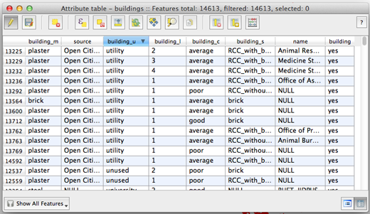
Shapefiles will often have additional files too which contain other information. A shapefile must be designated to hold only one type of feature (points, lines, or polygons), and each feature has it’s attributes contained in a table. Unlike the OpenStreetMap system in which every object can have an unlimited number of tags, the attributes of features in a shapefile must fit into the shapefile’s defined table structure, which might look something like this:
OpenStreetMap data can be converted into shapefiles. Various websites provide shapefiles converted from OSM data. These are discussed in the next chapter. DatabasesMany types of information are stored in database systems, which provide a logical way of organizing and accessing data. Geographic data is no different, although databases designed for geodata are specialized to handle the complex functions that querying geographic data requires. OpenStreetMap data is often stored in a PostgreSQL database with PostGIS extensions. This type of database provides fast access to the data and can be used easily with Mapnik, a piece of software that creates the map tiles used in web slippy maps. There are several tools available for importing raw OSM data into a PostgreSQL database. Another type of database is known as SQLite, which provides similar functionality as a PostgreSQL database, but is all stored in a single file and doesn’t require database software to be running. These are a little more difficult to create yourself, but can be easier to work with for small sets of data. SummaryIn the following chapters we will see how you can download data in various formats from the internet, and how you can use various tools to manipulate the raw data on your own.
Was this chapter helpful?
Let us know and help us improve the guides!
|