- Other guides
- Beginner's guide
- JOSM - Detailed Editing
- Coordination
- Mapping with a SmartPhone, GPS or Paper
- OSM Data
- HOT Tips - Getting started for new mappers - iD editor
- Starting with a Tasking Manager - iD editor
- Aerial imagery & Alignment - iD editor
- Issues - iD editor
- Tracing rectangular buildings - iD editor
- Tracing round buildings - iD editor
- Saving - changeset comment & Task Manager finishing a square - iD editor
- Tagging - iD editor
- Copying, Pasting & Rotating - iD editor
- Other Resources
|
|
Tracing rectangular buildings - iD editor
The Essentials
Points to note;
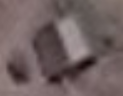
Buildings obscured or seen at an angle
It is common for the satellite image to be taken at an angle making the building seem distorted. In the above image the image to the right shows how the building should be traced. It is often easiest to trace the outline of the roof, then drag this to the point where the walls meet the ground - this was the technique used to trace the building above. Notice also that a building partially obscured by trees has been correctly traced as rectangular. Buildings with a ridged roofMost buildings either have corners at 90 degrees, or they are round buildings.
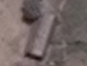
In isolated parts of the world it is common to use sheets of corrugated iron as roofing - when new these will reflect the sunlight which creates a very bright flare effect on the satellite imagery. It is common for buildings to have a verandah or be L shaped and you should ensure that your tracing follows the shape of the building. Do your best - even the experts will disagree sometimes, and sometimes you just have to go there to see exactly what is really there. If in doubt add it as a building. Building TagsAs we are tagging buildings we have never visited and are not familiar with, the safest and recommended tagging scheme is building=yes which you can see on a correctly tagged building if you scroll to the bottom of the tagging pane and click on All tags. See also
Was this chapter helpful?
Let us know and help us improve the guides!
|

 shows you which buttons or wheel on a mouse has been used, and which keyboard buttons pressed.