- Other guides
- Beginner's guide
- JOSM - Detailed Editing
- Coordination
- Mapping with a SmartPhone, GPS or Paper
- Surveying with a Garmin GPS
- Field Papers
- OsmAnd 2.0+
- OSMAnd
- Vespucci
- MapSwipe
- StreetComplete
- OSMTracker
- BasicAirData GPS Logger
- GPSLogger for Android
- GPS Essentials
- Go Map!!
- OSM Data
- HOT Tips - Getting started for new mappers - iD editor
- Other Resources
|
|
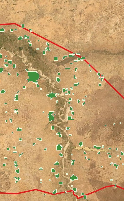
MapSwipeMapSwipe is a mobile app that aims to prepare satellite imagery for larger scale mapping in OpenStreetMap (OSM). With MapSwipe information, OSM mappers don’t have to spend valuable time scanning unpopulated areas (e.g. deserts or forests) or areas with poor quality data. Those have already been filtered out by Mapswipe. The red boundary in this picture marks the area of interest, the green areas are those accepted through Mapswipe as areas which contain features.
Mapswipe distinguishes itself from other forms of mapping by its simpleness and ease of use. How to use MapswipeFirst you have to choose your “mission”. Every mission contains several imagery tiles that you can swipe through. What you can do with the tiles depends on the mission-type
Request a projectMapswipe is developed by the Missing Maps Project. However, other organizations can request to use Mapswipe. See also
Was this chapter helpful?
Let us know and help us improve the guides!
|